It is said that new folks get hopelessly lost in the Pender Harbour area unless they’ve had a tour by boat to get a feel for the myriad waterways. Getting around by car with the sea on the right, no, the left, around the peninsula (but wait, didn’t we just drive over a bridge? Is this an island? Is that salt water or a lake? Are we still driving south? How is that possible?) and lakes can be really challenging at first. The newest way to get your bearings is to see some aerial photos of the area. It is hard to remember how properties sold or any of us found our way around before we could benefit from this eagle’s-eye view. And the aerial shots are breathtaking! We instantly see how blessed we are. So much forest, clean, fresh water, interesting and pristine shorelines! And when we feel stressed and it seems like troublesome humans are just everywhere, we are reminded that, in the Pacific Northwest at least, Nature still has the upper hand.
Laurent Wiese has all the qualifications and expertise in aerial photography to showcase our area to full advantage. He has a background as an aircraft maintenance engineer, he holds a pilot’s licence, and he has a passion for photography. His company, Skydrone Aerial Photography, offers a wide range of services in our area.
“My aerial photography offers a very cost-effective alternative to manned aircraft aerial photography for a variety of applications in the fields of real estate, building site progress reports, 3D mapping/ortho-photogrammetry, SAR, environmental planning and monitoring, agriculture, forestry, tourism, and archeology, among others. We also provide general photo and video services—the sky is the limit.”
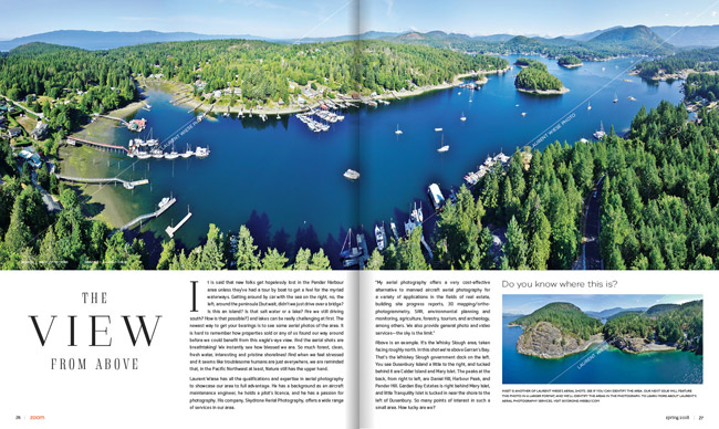
Above is an example. It’s the Whisky Slough area, taken facing roughly north. In this shot we’re above Gerran’s Bay. That’s the Whiskey Slough government dock on the left. You see Dusenbury Island a little to the right, and tucked behind it are Calder Island and Mary Islet. The peaks at the back, from right to left, are Daniel Hill, Harbour Peak, and Pender Hill. Garden Bay Estates is right behind Mary Islet, and little Tranquility Islet is tucked in near the shore to the left of Dusenbury. So many points of interest in such a small area. How lucky are we?
To learn more about Laurent’s aerial photography services, visit skydrone.weebly.com
Words | Nancy Pincombe


